
Dęblin 2025-03-05
Railway line No. 26 Łuków – Dęblin – Radom. 2025.
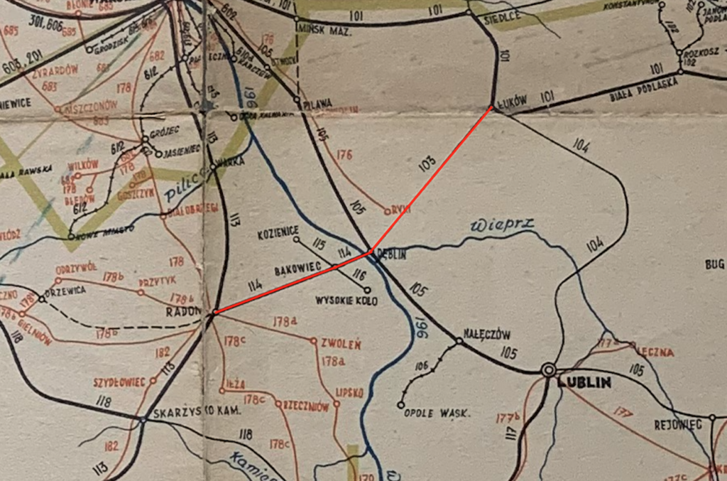
Railway line No. 26 Łuków – Dęblin – Radom is a double-track, electrified line built in the second half of the 19th century. It is currently 117.108 km long. The maximum speed of the train is 120 km/h.
In its history, the railway line No. 26 Łuków – Dęblin – Radom was initially part of two different railways, which were built as broad gauge (1,524 mm), in the times of the Kingdom of Poland, i.e. during the Moscow Partition. On December 2, 1876, the Łuków section (Warsaw – Terespol Iron Road) – Ivangorod (Dęblin) was built. The track to the Ivanogród station entered from the south. In 1935, a connecting line was built from the north, which enabled direct train travel, without changing the locomotive front, in the Łuków – Dęblin – Radom direction. On January 13, 1885, the Ivanogród (Dęblin) – Radom section was launched, together with a rail-road bridge over the Vistula River. This section belonged to the Ivanogród – Dąbrowa Iron Road.
Electrification with 3 kV DC current was carried out in the second half of the 20th century. The Dęblin – Radom section was electrified on December 28, 1967. The Łuków – Dęblin section was electrified on November 26, 1988.
In 2019, the revitalization of LK No. 26 was planned. Work was to start in June 2024. Unfortunately, the new government, the “December 13 coalition” (folksdeutsche, communists, freemasons) stopped these works. The plan was to replace the rails, sleepers and clean the ballast. The plan was also to repair the bridges. The plan was to build guarded automatic railway crossings. The main goal was to maintain a travel speed of 120 km/h. Initially, it was planned to spend 26 million zlotys on this purpose. But remember that LK No. 26 was not taken into account in the CPK Program.
The route of LK No. 26 Łuków – Radom.
Łuków station has an elevation of 166 m and there are four LK No. 2, 12, 26 and 30 at the station. Historically, it is the Warsaw – Terespolska Iron Road.
The line starts at Łuków station near LCS Łuków, and runs north-west. At the same time, it turns south in an arc. There are two tracks from the very beginning. The line crosses DK No. 63, Siedlecka Street, at a guarded rail-road crossing. Then there is a guarded crossing along Wiatraki/Ławecka Street. The line crosses the Krzna Południowa River. Then there is a guarded crossing along Poważę/Parkowa Street. On the western side of the line there is a grain elevator and guarded crossings; Objazdowa and Warszawska Streets (DK No. 76).
Łuków Łapiguz station (3.92 km, elevation 166 m) opened in 1876, under the name Łapiguz. There is one island platform at the station. Behind the station there is a guarded crossing along Żelichowska Street (DW Nr 807). Then a crossing along Spokojna Street. Then another crossing along the street of the local village of Szczygły Górne. The line crosses the Bystrzyca River.
Sarnów passenger stop (14.09 km, elevation 164 m), built as a loading station in 1910. Currently there are two single-edge platforms opposite each other and a road crossing. The line turns more towards the west.
Borowina passenger stop (16.90 km, elevation 163 m) opened on May 28, 1989. Currently there are two single-edge platforms opposite each other and a road crossing. The line enters the forests and crosses the Mała Bystrzyca River. Then there are two unguarded crossings.
The Krzywda passenger stop (22.55 km, elevation 174 m) was opened in 1876 as a loading station. Currently, there is an island platform here. The water tower has also been preserved. There is a guarded crossing along Łukowska Street.
Hordzieżka passenger stop (27.95 km, elevation 178 m) opened on 31 May 1992. Currently there are two single-edge platforms opposite each other and a road crossing along Andrzeja Kmicica Street.
Okrzeja station (30.94 km, elevation 178 m) opened in 1920. Currently there are two island platforms. Further on there is a crossing along Leśna Street.
Grabów Szlachecki passenger stop (35.26 km, elevation 179 m) opened on 1 June 1958. Currently there are two single-edge platforms opposite each other and a road crossing. Further on there are three road crossings.
Leopoldów passenger stop (42.20 km, elevation 180 m) opened as a station in August 1877, under the name Rossosz. The name was changed in 1878. The brick two-block station has survived. The majority of it has three storeys. Next to the station is the Leopoldów traction substation. Further on, the line winds, changing direction several times. There are agricultural areas here and four road crossings. The line runs under the S17 motorway (E375). The line crosses the Zalesionka River. DW No. 839 Lubelska Street runs above the track.
Ryki Ładownia railway station (51.51 km, elevation 139 m) opened in 1876. There is a former station here. Currently, it is only a freight station.
Ryki passenger stop (53.18 km, elevation 135 m) opened on December 9, 2017. There are two single-edge platforms set in a passing loop, separated by the Juliusza Słowackiego Street crossing. A siding from the Stawy Military Logistics Base joins here.
Stawy freight station (55.71 km, elevation 128 m) launched on June 5, 1925. Here is a fork in the line to reach Dęblin station from the north or south. Before Dęblin station, the line becomes single-track, to become double-track again in the northern head of the station. In reality, traffic is grade-separated.
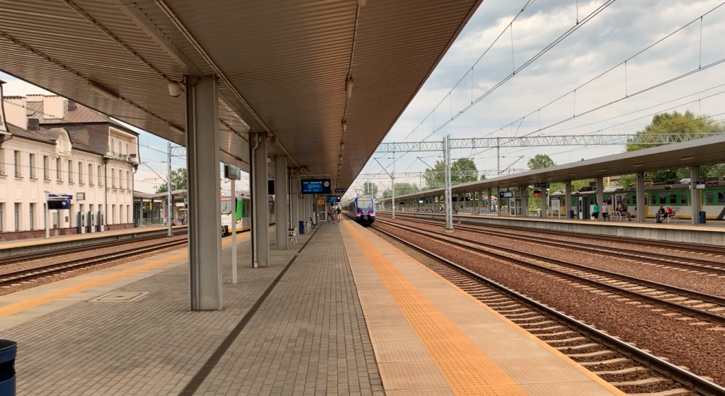
Dęblin station (61.44 km, elevation 119 m) launched on August 17, 1877, under the name Ivanogród. The name was changed in 1918. The line runs at Platforms 2 and 1. Then it curves south and bypasses the freight station.
Dęblin goods station (62.57 km, elevation 119 m). Next, the line runs under DK No. 48 Warszawska Street. On the eastern side, it passes the Dęblin power station. Then, LK No. 7 branches off from the line to the south to Lublin, and LK No. 26 turns west. Then there is a ride along Podchorążych Street. There is a Wisła “Wi” checkpoint (64.88 km, elevation 119 m) and a connecting line No. 580 from the direction of Lublin. The tracks enter the railway bridge over the Vistula River (65 km, elevation 117 m). The line leaves the Lublin province and enters the Mazovian province. There are several arches here.
Zajezierze station near Dęblin (67.04 km, elevation 116 m) launched in 1923. Currently, it is a passenger stop. Further on the line there is a crossing along DW No. 691.
Bąkowice Station (74.95 km, elevation 120 m) launched in 1915. Here the line to Kozienice branches off. The line crosses DW No. 738.
Garbatka Letnisko Station (81.98 km, elevation 153 m) launched in 1885. Behind the station there is a crossing, Skrzyńskich Street. The line enters Kozienicki Landscape Park. Further on the line crosses DK No. 79.
Żytkowice Station (87.20 km, elevation 159 m) launched in May 1951. Here there is a huge PKP plant repairing railway infrastructure. There is also a House Factory here, as well as a prison. Further on the line crosses the Zagożdżanka River.
Pionki station (93.94 km, elevation 152 m) opened in 1885, under the name Zagożdżon. The name Pionki has been in use since 1933. There is one island platform here.
Pionki Zachodnie passenger stop (95.71 km, elevation 154 m) opened on May 14, 1950, temporarily as Pionki Wytwórnia. There are currently two single-edge platforms.
Jedlina Kościelna passenger stop (98.66 km, elevation 167 m). There are two single-edge platforms opposite each other. Next to it is a passage along Sokoły Street.
Jedlina Letnisko station (104.99 km, elevation 162 m) opened in 1885. Then the line crosses the Pacynka River.
Groszowice Wrzosów passenger stop (106.79 km, elevation 159 m) launched on January 2, 2023. There are two single-edge platforms opposite each other and a passage along Akacjowa Street.
Antoniówka passenger stop (108.51 km, elevation 166 m) launched in June 1951. There are two single-edge platforms opposite each other and a passage along a local street.
Rajec Poduchowny passenger stop (110.59 km, elevation 177 m) launched on May 28, 1972. There are two single-edge platforms opposite each other and a passage along a local street. Then the line passes under DK No. 12, then under DK No. 9 and 12 (Aleja Wojska Polskiego).
Radom Wschodni freight station (116.51 km, elevation 167 m) launched in 1945. The line connects with LK No. 8 Warsaw – Kraków. The line passes under Lubelska Street.
Radom Główny station (118.11 km, elevation 166 m) launched in 1885, as Radom. The name Radom Główny has been in effect since 2021. The line ends at Platform 3.
Railway bridge over the Vistula.
The bridge was built in the period 1883-1885, for the Ivanogród – Dąbrowa Railway. The bridge was made as a railway-road bridge. The Italian specialist Forradini was employed to supervise the construction of the bridge. Italian stonemasons were brought in to build the bridge. The bridge abutments and pillars were made of granite and sandstone. The bridge was made in accordance with the latest solutions, with a riveted structure. The bridge is 1,400 English feet long and was made in the Dutch system. Each span was made as a tunnel truss, with constant dimensions along its entire length. Individual elements were made in the Ostrowiecka Steelworks and in other plants in the Kingdom of Poland. The bridge has two abutments and 4 pillars, which were made mainly of granite. The bridge caissons are immersed in the riverbed, to a depth of 17 m, below the water surface. Brick watchtowers were built by the bridge.
During the Great World War, retreating Muscovites blew up the bridge. They destroyed all the spans, except for one, where the charges did not explode. The Austrian army quickly built a wooden bridge and laid a single track on it. The base for the track was made of steel elements of the destroyed bridge. This bridge was built on the southern side of the destroyed bridge. Additionally, a wooden footbridge (walkway) was built for pedestrian traffic, which was placed between the bridges; the destroyed and the temporary one. The destroyed bridge was rebuilt to carry a single track. Road traffic was also allowed over this bridge. The individual spans differed from each other.
In the 1920s, the bridge was rebuilt and new truss spans were installed, which are parabolic at the top. Only one track was laid on the bridge, because it was a rail-road bridge. The road crossing was eliminated when a new road bridge was built nearby. In September 1939, Polish sappers damaged the bridge to stop the German attack.
The current bridge, which dates back to the 1920s, is 448 m long. It has five spans, each 88 m long. The bridge caissons are immersed in the riverbed, 17 m below the water surface. The width of the spans is 8.50 m, which allows for the laying of two tracks. The tracks on the bridge are electrified.
Written by Karol Placha Hetman