Szreniawa 2024-08-02
Geographical coordinates: 52.316N 16.796E. Elevation 87 m (285 ft).
The town of Szreniawa near Poznań.
Szreniawa is located in Poland in Wielkopolskie Voivodeship (Greater Poland Province), in the district of Poznań, in the municipality of Komorniki. The distance to Poznań is 16 km. In 2011, the village had a population of 652 inhabitants. During the German occupation, the village was called Marienberg.
The Szreniawa estate was established on the land of Rosnowo, as a Polish nobleman’s village already in the Middle Ages. The owners were a noble family of the Szreniawa coat of arms. In 1852, the noble owner Antonina Pomorska, widow of Jan Pomorski, sold the village to a Prussian named Hermann Bierbaum. The new owner, in 1855, began building a palace with a park. He also expanded the manor and founded a brewery, distillery and brickyard. In 1864, the name of the estate was changed to the Germanic Marienberg. The Prussian family was so greedy that they even built themselves a mausoleum. After the victorious Greater Poland Uprising, Dr. Jozef Glabisz bought the estate out of Germanic hands. He introduced modern farming methods and mechanised field work. Due to new regulations, he liquidated the distilleries as the Polish Spirits Monopoly was established, but continued to run the brewery. After the Germanic invasion of the Republic of Poland, the Glabisz family was expelled. Participants in the Wielkopolska Uprising were subjected to particular repression. The estate came under Germanic administration. After the Second World War, the new communist authorities nationalised the estate and a state farm was established.
In 1962, the Ministry of Agriculture decided to establish the National Museum of Agriculture and Agro-Food Industry on the estate. Today, it is the largest museum of its kind in the world. The museum is a destination for many inhabitants of Wielkopolska and Poland. You can spend a whole day here. The National Museum of Agriculture in Szreniawa is located in the vicinity of railway line No. 357 Poznań – Wolsztyn, which runs trains to Poznań, Grodzisk Wielkopolski and Wolsztyn. In front of the museum entrance itself, 100 metres away, there is the Szreniawa railway station. The train journey time from Poznań Główny train station is up to 17 minutes. Therefore, the fastest way to get from the centre of Poznań to Szreniawa is by train.
In the period 1975-1998, Szreniawa belonged to the province of Poznań.
The word Szreniawa is primarily the Polish coat of arms of the nobility, which bears the name Średniawa or Ocele. The coat of arms as a seal has been used since 1371, and appears in records since 1403. The coat of arms is mentioned in the oldest surviving Polish coat of arms; Insignia seu clenodia Regis et Regni Poloniae. It was also written down by the historian Jan Długosz in 1464. The Szreniawa coat of arms is one of the 47 coats of arms adopted by the Lithuanian boyars by virtue of the horodela union, dated 1413. The coat of arms depicts a white river crowned by a cross, on a red shield.
Szreniawa railway station near Poznań.
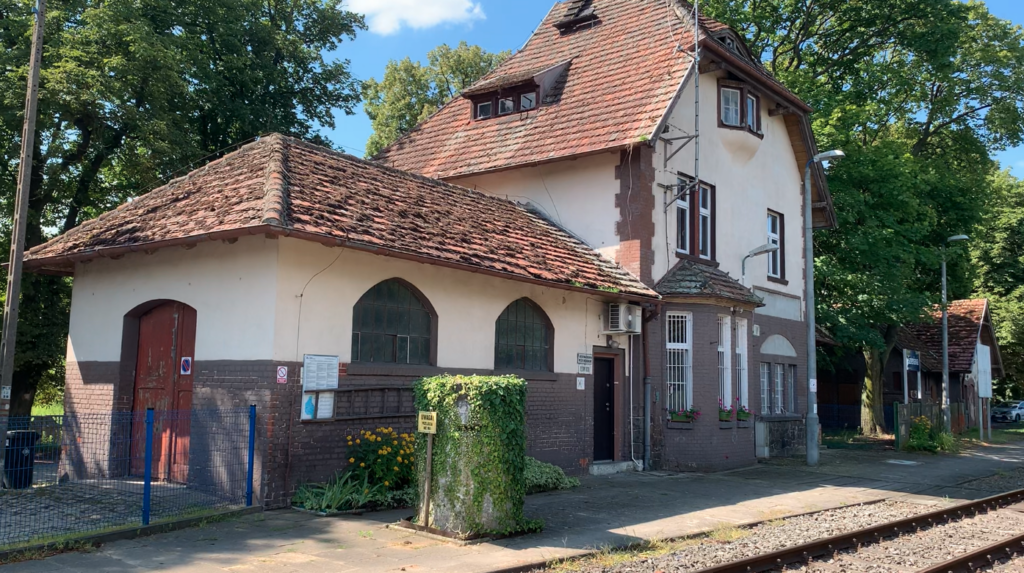
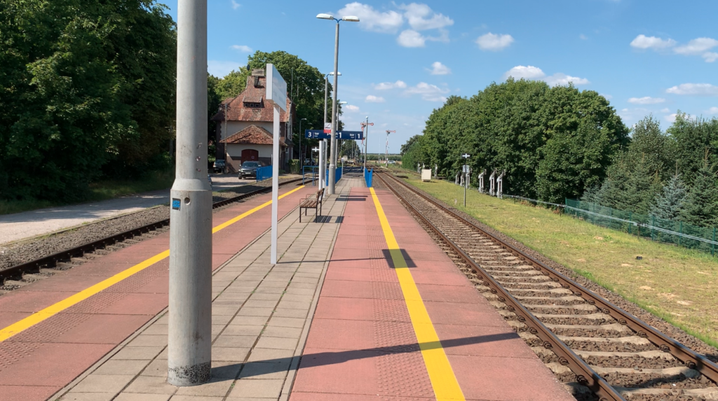
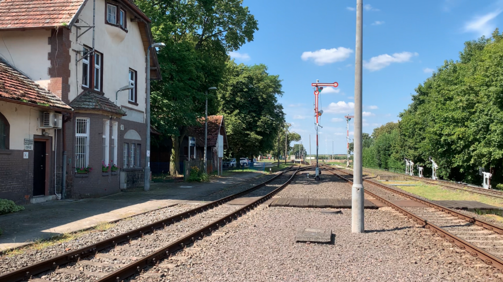
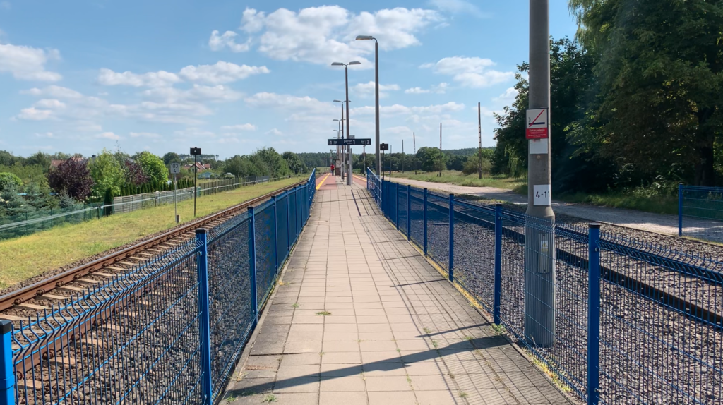
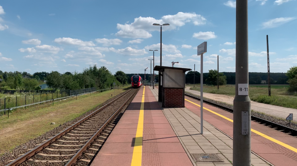
The Szreniawa railway station near Poznań was opened on 1 July 1909, during the Germanic occupation of Greater Poland. The station is a through station and has never been a junction station. The station is located on railway line no. 357 Sulechów – Luboń near Poznań.
Originally the station had two through tracks and two side tracks. There were two single-edge platforms. The second platform was of the island type, typical of the late 19th/early 20th century. Both platforms were of the low level type and had a paved surface with flagstones. Access to the platforms was and is at rail level. The station had street lamp lighting along Platform No. 1 and further along the storage yard.
After refurbishment in 2011, the station was given the role of a passing station for passenger trains and has two tracks and two ribs. All sleepers are prestressed concrete. Track number 1 has spring fixings and track number 3 has bolted fixings. A section of side track has been left in place with no access. A new island double-edge platform of the high-rise type, 200m long and 5.5m wide, has been built between the tracks. The platform has a bus shelter, benches, information display cases, a sound system and lighting. The surface of the platform is made of prefabricated slabs, 2 m x 1 m, maroon in colour, which are edge plates. The rest is paved with flagstones.
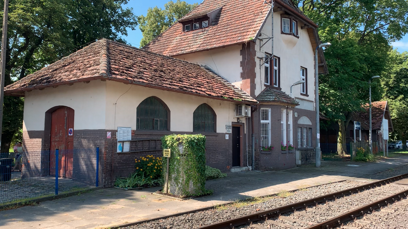
There is a typical station building at the station, which still fulfils its role today. The building stands on the south side of the station level. There is no ticket office or waiting room in the building, but historically they existed. The station houses the signal box. An outbuilding was erected next to it. There were no maintenance facilities at the station such as a water tower, water cranes, locomotive shed or coal entanglements. There was only a storage yard and an unloading ramp, front and side. In the western part of the station, on the extension of track No. 3a, there is a loading ramp, but it is disused.
At Szreniawa station there are centralised, mechanical traffic control devices. Shaped semaphores are still in operation. Due to the historic nature of the station, the existing traffic control equipment has been left in place. Only the warning discs were replaced with luminous ones and through-warning discs were added. The mechanical horns on the level crossing located on the Stęszew side are operated from the signal box.
In 2012, it was reported that the railway station in Szreniawa will change hands. It will become the National Museum of Agriculture and Food Industry in Szreniawa. However, this does not mean that the museum will be in charge of railway traffic. There were plans for a waiting room and a section of the museum; Railways in Agriculture. We do not know the final outcome of this intention.
Currently (2024), the station is used as a passing station on a single-track route. In 2017, the station was used by up to 100 passengers per day. In 2022, traffic included up to 150 passengers per day. In July 2024, from Szreniawa station it was possible to travel to: Poznań Główny, Grodzisk Wielkopolski, Wolsztyn, Wągrowiec. There are 40 trains stopping at the station per day. All relations are operated by Wielkopolska Railways. The rolling stock is: 36WEHD hybrid (2 units), SA132 (11 units), SA134 (2 units), SA139 Link (2 units).
Railway line no. 357 Sulechów – Wolsztyn – Luboń near Poznań.
Railway line No. 357 is 112.182 km long. It is single-track, non-electrified, with a maximum speed of up to 110 km/h and a gauge of 1435 mm. The route was built in stages from 1904 to 1909, and was also put into service in stages. On 1 April 1905, the Sulechów – Wolsztyn section was put into service. On 1 July 1905, the Wolsztyn – Grodzisk Wielkopolski section was opened. On 1 July 1909, Grodzisk Wielkopolski – Luboń near Poznań (end of railway line No. 357).
By January 1934, the cross-border section Kargowa – Kopanica had been dismantled. The PKP company was not interested in maintaining a border crossing at this location. After the Germanic aggression against Poland, on 1 September 1939, freight and passenger traffic was restored on the Kargowa – Kopanica section.
In 1994, passenger train traffic was halted on the Sulechów – Wolsztyn section. In July 2005, freight traffic was halted on the Sulechów – Powodowo section. At the same time, the Sulechów – Okunin section needed repairs and was declared impassable. In June 2009, the section Żodyń – Powodowo was repaired on national road No. 32 and the tracks at the level crossing were removed. At the same time, also on the section Okunin – Smolno Wielkie, the tracks on the level crossing on national road No. 32 were removed.
In March 2011, the renovation of the section Stęszew – Luboń near Poznań (end of LK No. 357) began, together with the renovation of stations and railway stops. In 2012, rail traffic was restored. In July 2011, passenger traffic was closed on the Wolsztyn – Stęszew section. Renovations began, which were completed in January 2012, and rail traffic was opened.
In July 2011, freight traffic was closed on the Grodzisk Wielkopolski – Stęszew section. In June 2014, the renovation of this section began. The modernisation was completed at the beginning of 2015. Due to the ongoing renovation of the railway viaduct, traffic was restored after its completion. A replacement bus service was in operation. Rail traffic resumed in December 2014.
The Sulechów – Wolsztyn section lost its importance the fastest. It was 38 km long. In 1994, rail traffic was suspended on it. In 2015, the tracks on the Sulechów – Powodowo section (the first station from Wolsztyn) were dismantled. The tracks at several level crossings remained. Among others through DW Nr. 314, Smolno Wielkie, Sulechów (three crossings). Some crossings still have St Andrew’s Crosses. Some station buildings remain: Żodyń, Kopnica, Kargowa, Smolno Wielkie (there are shaped semaphores), Okunin (the station is visible from DW Nr 304). The steel railway bridge Kopnica on the North Obra Canal, the bridge on the Dźwiński Canal, the bridge on the Obrzyca Canal, the bridge on the Obra Canal remain. Track remains in the vicinity of Kargowa. Remaining tracks are in Sulechów on Brzozowa Street, just before the station.
On 14 March 2011, the renovation of the 65 km Wolsztyn – Luboń section began. The track bed was replaced over a total length of 73 km. New platforms were built at the stations: Tłoki, Rakoniewice, Ruchocice, Grąblewo (new stop), Kotowo, Granowo, Strykowo, Stęszew, Trzebaw, Szreniawa and Wiry. Railway-road crossings were modernised: DK No. 32 (3 crossings), Grodzisk Wielkopolski (9 crossings), Granowo, Stęszew, Szreniawa. New railway traffic control devices were installed. The cost of the modernisation was PLN 84 million. Passenger trains (rail buses and SZT) run on this route at a maximum speed of 110 km/h. The route is operated by Wielkopolska Railways.
The Wolsztyn – Grodzisk Wielkopolski section was overhauled between January 2022 and March 2023.
Mileage of line No. 357.
Sulechów 0.335 km. Okunin 6.859 km, decommissioned. Smolno Wielkie 13.266 km, decommissioned. Chwalim 16.759 km, decommissioned. Kargowa 19.505 km, decommissioned. Kopanica 25.177 km, decommissioned. Żodyń 30.232 km, decommissioned. Powodowo 34.606 km, decommissioned. Powodowo Xella 35.327 km. Wolsztyn Skansen 38.000 km. Wolsztyn 38.858 km. Adamowo 43.500 km. Tłoki 45.368 km. Rostarzewo 49.377 km. Rakoniewice 53.489 km. Drzymałowo 56.462 km. Ruchocice 60.291 km. Młyniewo Nowotomyskie 64.145 km, decommissioned. Grodzisk Wielkopolski 67.769 km. Grąblewo 70.965 km. Ptaszkowo 74.400 km, decommissioned. Ptaszkowo Wielkopolskie 74.623 km. Kotowo 77.250 km. Granowo Nowotomyskie 80.698 km. Strykowo Poznanskie 87.686 km. Stęszew 95.467 km. Trzebaw Rosnówko 99.997 km. Szreniawa 104.348 km. Wiry 108.208 km. Luboń near Poznań 112.182 km.
Written by Karol Placha Hetman
Leave a Reply
You must be logged in to post a comment.