
Katowice 2025-02-01
Description of the railway route No. 1.
Currently, Railway Line No. 1 Warsaw West – Katowice is largely the former Warsaw – Vienna Railway Road. The length of LK No. 1 is 316.066 km. The line is double-track, electrified with 3 kV DC current, and the maximum speed is 160 km/h. The rail gauge is 1435 mm. The line runs meridionally. In the Polish railway system, it is the third alternative route that connects Silesia with Warsaw, and which complements LK No. 4 CMK (via Opoczno, Włoszczowa) and LK No. 8 (via Radom, Kielce, Olkusz). On LK No. 1 is installed; SHP system, automatic blocking semaphores, automatic rail-road crossings with or without barriers. There are a dozen or so guarded rail-road crossings on the trail, which are operated by crossing keepers.
We will describe LK No. 1 from the Katowice side, i.e. we will follow track No. 2, and the mileage will decrease. We start the description from the Katowice railway station, where there is 316.006 km of LK No. 1. This is the Śródmieście district, the center of Katowice, elevation 270 m. Currently (2025), the track system and platforms at Katowice station are being renovated. Platform 1 is the first to be renovated. The trail leads eastward, and the LK No. 1 tracks are located on the northern side of the track. The railway viaduct crosses Jana Kochanowskiego Street at the top. Then there is a pedestrian and bicycle tunnel for the first station in Katowice, a viaduct over Francuska Street, a viaduct over Konstantego Damrota Street, a viaduct over Graniczna Street. Then, on the southern side, there is the PKP Intercity locomotive shed. Under the tracks runs DK No. 86, Murckowska Street. On the southern side is Huta Ferrum.
Katowice Zawodzie Station (315.65 km, elevation 264 m). From this station, sidings run to Huta Ferrum and other factories. The tracks run under Bagienna Street, DK No. 79. The tracks still run through industrial areas, including the Szopienice Power Plant.
Passenger stop Katowice Szopienice Południowe (312.91 km, elevation 263 m). Behind the platforms, the tracks run above Lwowska Street. Then the routes split. To the south, the tracks turn towards Mysłowice, and to the south, LK No. 1 turns towards Sosnowiec. In the intermarium, there is a Szopienice traction substation. Above LK No. 1, the tracks from the Katowice Szopienice Północne railway station run. The tracks cross the Rawa River. The route runs between the lakes; Hubertus and Morawa, and then crosses the Brynica River. During the partitions, there was a border between Muscovites and Germans here. Then, from LK No. 1, a single track branches off to the Sosnowiec Południowa station, and a little further on, a track from the same station, the No. 660 Sosnowiec Południowy – Sosnowiec Główny connecting line, joins. So from the Sosnowiec Południowy station it is possible to travel towards Katowice and Warsaw, along LK No. 1 and eastwards to Olkusz, LK No. 62. There is a viaduct over Marszała Józefa Piłsudskiego Street.
Sosnowiec Główny railway station (309.54 km, elevation 255 m). On the north-west side there are traces of industrial tracks that led, among others, to coal mines: Milowice, Czeladź, Saturn and other industrial plants. LK No. 1 runs under the viaduct of Orla/Parkowa Street. Then the trail crosses Stefana Żeromskiego Street at the top. On the west side there are more industrial areas; Severstal, Rohrwerk Maxhutte and others. There are numerous former residences of manufacturers in the area. The line heads north and passes the Czarna Przemsza River.
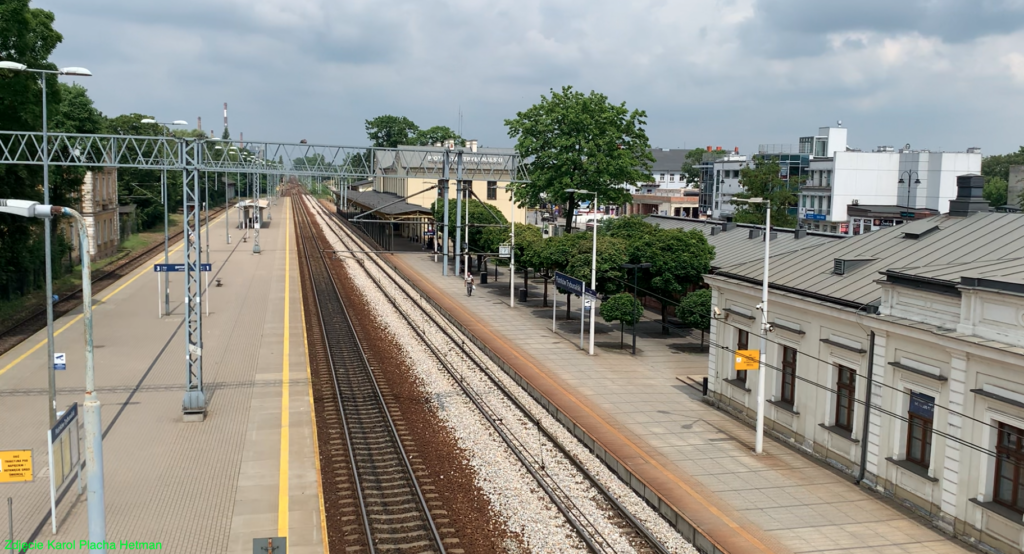
Sosnowiec Środula passenger stop (307.08 km, elevation 255 m). The stop was put into service in 2025. The stop has two single-edge platforms with roofing. The line runs under DK No. 94, Aleja Zagłębia Dąbrowskiego.
Będzin railway station (305.56 km, elevation 255 m). The station was launched on August 24, 1859. There is a very nice station building at the station. Its main part is two-story, five-axle, and the side wings are single-story, also five-axle. There is a large bus station at the railway station, on the western side. There are many industrial plants nearby.
Passenger stop Będzin Miasto (304.38 km, elevation 260 m). The stop has two single-edge platforms that are covered. The line runs under DW No. 910, Aleja Hugona Kołatają. The line turns eastward. Despite numerous workplaces, there is a lot of greenery here.
Passenger stop Będzin Ksawera (302.07 km, elevation 262 m). The stop was launched on May 1, 1956, on the communist holiday. The first train to stop at the stop was an EZT on the Kielce – Katowice route. There is an island platform at the stop, which was last renovated in 2010. Right behind the platform is a rail-road crossing along Siemińska Street. On the right side of the tracks are the areas of the former KWK Paris mine and there is Huta Bankowa.
Dąbrowa Górnicza Station (300.12 km, elevation 267 m). The station was opened in 1859. Currently, there is one island platform at the station. There is also a beautiful red brick station, which is currently not used. Nearby are large parking lots and a bus station. Behind the station, Kolejowa Street runs underneath.
Dąbrowa Górnicza Gołonóg Station (296.72 km, elevation 278 m). The station was opened in 1885. There is a large station with a characteristic tower. Currently, there are two single-edge platforms here. Behind the station, Parkowa Street runs underneath the tracks. Further on, there are numerous old tracks to factories that are no longer in use.
Dąbrowa Górnicza Pogoria Passenger Stop (295.39 km, elevation 281 m). The name of the stop comes from the Pogoria water reservoirs. The stop was opened on May 31, 1970 and is open seasonally; from March to September. Further on, the track crosses Saint Antoni Street at a rail-road intersection and runs under the S1 Motorway. On the eastern side, you can see the grounds of the Katowice Steelworks, which was founded in 1972 as the largest steelworks in Poland. Here, the tracks converge; the Warsaw-Vienna Iron Road from the direction of Sosnowiec Maczki, the sidings from the Katowice Steelworks and from the western side, the tracks from the Łagisza Power Plant.
Dąbrowa Górnicza Ząbkowice railway station (292.89 km, elevation 298 m). The station was built in 1848. There are three platforms and five platform edges at the station. There was a footbridge over the tracks at the station, but it was replaced with an underground passage. The freight section of the station has 10 tracks. On the eastern side there is an impressive retaining wall, which protects the neighboring buildings of the city. DW No. 796, Armii Krajowej Street, runs under the tracks of the freight section. Two routes run parallel from the station; LK No. 1 and LK No. 189.
Passenger stop Dąbrowa Górnicza Sikorka (289.20 km, elevation 314 m). The stop was opened on October 2, 1938. There are two platforms and three platform edges here. The platforms are separated by a rail-road crossing along Halerczyków Street. Further on is the border of the vast city of Dąbrowa Górnicza, and at the same time the Upper Silesian-Zagłębie Metropolis. 287 km; LK No. 1 and LK No. 189 routes separate. DW No. 796, Powiatowa Street, runs above the tracks.
Chruszczobród passenger stop (286.55 km, elevation 326 m). The stop was built on October 2, 1938 and was called Bugaj until May 15, 1939. Currently, there are other railway lines in the area.
Wiesiółka passenger stop (284.34 km, elevation 325 m). The stop was opened on June 2, 1991. There are two platforms and three platform edges here. The stop is already within the boundaries of the Łazy station turnouts.
Łazy station (280.65 km, elevation 345 m). This is the highest point of LK No. 1. Here are LK No. 1, 154, 160, 186. The station was opened on December 13, 1847. Currently, it is a large freight station, with a very extensive track system. There is a large locomotive shed, workshops, social buildings, a water tower, several railway signal boxes, etc. The station tracks stretch for 8 kilometers. In the passenger section there are two island platforms, four platform edges, and a footbridge above the platforms. A few years ago, the platforms were renovated and elevators were installed. At the station stands a technical monument; Locomotive Ty45-421. At the station there is a typical viaduct-tunnel for four tracks with a reinforced concrete structure. Such facilities were built in Poland in the 50s of the 20th century.
Zawiercie Station (274.22 km, elevation 333 m). The station was built in 1847. There is a nice, well-kept and large station building here. At the Zawiercie station there are LK No. 1, 4, 160, 182, 186. This is the beginning of LK No. 4, or CMK. There are two platforms and three platform edges here. The platforms are roofed. There is a tunnel for travelers. Behind the station, above the tracks runs DK No. 78, Wojska Polskiego Street. Then the line crosses the Warta River.
Passenger stop Zawiercie Borowe Pole (270.30 km, elevation 321 m). The stop was opened on June 1, 1953. Above the stop is the viaduct of Borowe Pole Street.
Passenger stop Myszków Mrzygłód (266.37 km, elevation 310 m). The stop was built in May 1951. There are two single-edge platforms and a concrete footbridge over the tracks. At this point, the CMK (its tracks) branch off to the sides and arc eastwards. The western track of LK No. 4 of CMK No. 1 crosses LK No. 1 on a truss bridge.
Myszków Światowid passenger stop (263.44 km, elevation 300 m). The stop was opened in October 1946, under the name Światowid. The name was changed in 1966. There are industrial areas nearby, including the Myszkowska Enamelware Factory.
Myszków Station (263.44 km, elevation 300 m). The station was built in December 1847. An impressive and well-maintained station was built of red brick. Currently, the station has two platforms and three platform edges. Under the platforms runs a tunnel for pedestrians and travelers. Behind the station, above the tracks runs DW No. 793, Kazimierza Pułaskiego Street. Myszków Nowa Wieś passenger stop (257.52 km, elevation 291 m). The stop was opened on May 26, 1968, under the name Nowa Wieś Żarecka. In 1975, the name was changed to Myszków Nowa Wieś Żarecka, and in 1980, to the current name Myszków Nowa Wieś. Further on, the line crosses DW No. 789, Koziegłowska Street, at a rail-road junction. The line enters the forest.
Passenger stop Żarki Letnisko (254.08 km, elevation 289 m). The stop was established as Żarki in 1921. The name Żarki Letnisko was given in 1969. Żarki is a very interesting summer resort located in pine forests. 2,750 people live here (2020).
Passenger stop Masłońskie Natalin (250.78 km, elevation 282 m). The stop was opened on May 20, 1951, as Natalin. The current name has been in use since 1966. There are two single-edge platforms here. At the stop there is a railway-road intersection with Jurajska Street. The lines are also crossed by the Ordonka River.
Poraj Station (246.46 km, elevation 272 m). Launched on 13 December 1847. There are 7 tracks in the freight section. There is LK No. 155 (length 11 km), which is an additional single-track electrified branch line to Kucelinek, to Częstochowa Steelworks and Częstochowa station. Passenger trains sometimes run here. 244 km, an old track runs over the top, which led the track into the forests near Olsztyn; line of unknown purpose. We cross the Warta River.
Korwinów passenger stop (239.15 km, elevation 259 m). The stop was opened in 1921, under the name Słowik. In June 1926, the name was changed to Korwinów. A small station was built. Currently, there are two single-edge platforms, and at the platforms there is a rail-road intersection along Stacyjna Street. Korwinów is a small village inhabited by 563 people. The village, together with other villages; Słowik, Nowa Wieś, Wrzosowa, forms a large cluster in the Poczesna commune. The line crosses the railway-road intersection DK No. 46, Bugajska Street. Further on, the large Częstochowa railway junction begins, where several railway lines cross. The line passes the Częstochowa Steelworks on the western side.
Częstochowa Raków passenger stop (233.40 km, elevation 251 m). The stop was opened in 1921, under the name Błeszno. In 1948, the name was changed to Częstochowa Błeszno, and in 1966, to Częstochowa Raków. Practically, the stop is part of the Częstochowa Towarowa freight station. The line runs under Aleja Pokoju Street, and behind the freight station, under the viaduct of DK No. 46 and 91, Aleja Wojska Polskiego. The line crosses the Stradomka River, which is a left tributary of the Warta River.
Częstochowa Railway Station (229.74 km, elevation 249 m). The station was opened on November 17, 1946. In the period 1991-1997, the station was called Częstochowa Osobowa. Right behind the station, Aleja Najświętszej Maryi Panny runs uphill, which leads straight to Jasna Góra; the Sanctuary of the Polish Nation. Then the line crosses DW No. 483, Aleje Jana Pawła II, uphill. At 228 km and 227 km, there are guarded rail-road crossings. At 226 km there is a pedestrian and cyclist crossing. Then, at the top, it crosses DK No. 1, Aleja Wojska Polskiego.
Częstochowa Aniołów passenger stop (225.81 km, elevation 250 m). The stop was built in May 1929, under the name Aniołów. In 1957, the name was changed to Częstochowa Aniołów. There are two single-edge platforms here, and in front of them a rail-road intersection along Jana Andrzeja Morsztyna Street. At 224 km there is a guarded rail-road crossing along Jana Karłowicz Street. At 223 km there is a viaduct over Wypoczynku Street. At 222.75 km there is a line separation into the direction of Radomsko LK No. 1 and Marchewki LK No. 146 and then Zduńska Wola. LK No. 1 runs over track No. 2 LK No. 146. On the northern side of the line is Rudniki Airport, previously military, currently civilian. On the southern side are the Rudniki Chemical Plants. Nearby are the Rudniki cement works and the Lipówka quarry. At 218 km there is an automatic rail-road crossing.
Rudniki station near Częstochowa (217.70 km, elevation 253 m). The station was launched in 1846. The name was changed several times; Rudniki – Rudniki near Częstochowa. There is one island platform at the passenger station, and access is via a footbridge over the tracks. Sidings to nearby factories branch off from the station. At 217 km there is a footbridge over the tracks. After the station, 216 km, the line runs under DK No. 91, Warszawska Street. At 212 km there is an automatic rail-road crossing.
Rzerzęczyce passenger stop (210.60 km, elevation 245 m). The stop was opened on October 5, 1952. There are two single-edge platforms here. There is a guarded rail-road crossing here, operated by a trackman, Witkowska Street.
Kłomnice Station (208.20 km, elevation 238). The station was opened on December 13, 1846. There are 6 tracks at the station. There are two platforms and three platform edges. The station is a single-storey building. Access to the platforms is at the level of the tracks. The “KŁ” signal box is a two-storey building. There are several other historical buildings at the station. At km 207, DK No. 91 runs uphill. At km 206, 204, there are automatic rail-road crossings.
Przystanek osobowy Jacków (202,73 km, elewacja 220 m). Przystanek uruchomiono w dniu 2 czerwca 1991 roku. Są tutaj dwa jednokrawędziowe perony. Przy peronach jest automatyczny przejazd kolejowo-drogowy, ulica Dworcowa. Na 201 i 200 km są automatyczne przejazdy.
Widzów Teklinów passenger stop (200.52 km, elevation 221 m). The stop was opened in 1846, under the name Widzów, in 1919, the name was changed to Teklinów, and in 1990, it was named Widzów Teklinów. There are two single-edge platforms here, and the access is at the level of the tracks. There are 5 tracks in the freight section. Behind the station there is a guarded rail-road crossing. At 198.90 km is the border of the Silesian and Łódź provinces. The line crosses the Warta River (195 km) and a little further the Radomka River.
Bobry passenger stop (194.70 km, elevation 210 m). The stop was put into service on March 11, 1949. There are two single-edge platforms here, and the access is at the level of the tracks. The rail-road crossing is automatic. At 191, 190, 189 km there are automatic rail-road crossings. At 189 km, DK No. 42 runs uphill, Brzeźnicka Street.
Radomsko Station (189.13 km, elevation 225 m). The station was opened on December 13, 1846. In front of the platforms there is a rail-road crossing, Tadeusza Kościuszki Street. Radomsko is an industrial city, so several sidings branch off from the station. The station has one island platform with access at track level, an impressive single-storey station, a very long ramp and a large storage yard, a water tower, a container terminal, the Radomsko traction substation and others. There are 7 tracks in the freight section. There is a passage through these tracks along Józefa Ignacego Kraszewskiego Street. At 187, 185 km there are guarded rail-road crossings, serviced by a crossing keeper. At 185 km there is a viaduct over the Radomsko bypass tracks.
Dobryszyce passenger stop near Radomsko (183.43 km, elevation 228 m). The stop was opened on May 2, 1948, under the name Dobryszyce, and in 1950, the name was changed to the current one. There are two single-edge platforms here. In front of the platforms there is an automatic rail-road crossing along Dobryszycka Street. At 182 km there is an automatic rail-road crossing with lights without barriers. An acoustic system is installed along the route to scare animals away from the approaching train. At 180, 179 km there are automatic rail-road crossings. At 179 km the line crosses the Widawka River.
Gomunice station (177.69 km, elevation 220 m). The station was built in 1860, under the name Kamińsk. In 1951, the name was changed to Kamińsk Radomszczański. Currently, there are two single-edge platforms at the station. Behind the platforms there is a guarded rail-road crossing. There is a “Gm” signal box. In the goods section there are 6 platforms, a ramp and a large storage yard. The main commodity is wood. There is an observation point for railway enthusiasts at the station. At 175 km the line runs under the viaduct DK No. 91.
Kamieńsk passenger stop (174.97 km, elevation 220 m). The passenger stop was built in 1924, under the name Nowy Kamieńsk. The current name has been in use since 1962. At the station there is a historic station building from 1924, at a guarded rail-road crossing, Kolejowa Street. There are two single-edge platforms here. At 173 km there is an automatic rail-road crossing with lights without barriers. At 172 km there is an automatic rail-road crossing, but drivers are required to slow down to 20 km/h, because visibility is very limited due to high hills. This is where the forest areas end and the agricultural areas begin.
Gorzędów passenger stop (171.58 km, elevation 219 m). The stop was opened on 5 October 1952. Behind the platforms there is an automatic rail-road crossing, Adama Mickiewicza Street. At 170, 168 km there are automatic crossings with lights without barriers. On the western side you can see the beautiful Roman Catholic Church of the Sacred Heart of Jesus in the town of Gorzkowice.
Gorzkowice station (166.71 km, elevation 209 m). The station was launched in 1860. The station has a large ramp, a large storage yard, a large “Gr” signal box with a guarded rail-road crossing, one island platform, a single-storey station, and 5 tracks in the freight section. There is a siding to the Consolis H+H factory, which produces reinforced concrete structures. The factory’s technological bridge runs over the tracks. At 165, 163 km there are automatic crossings with lights without barriers.
Wilkoszewice passenger stop (162.52 km, elevation 198 m). The stop was built in 1953. A small station with a ticket office and a waiting room was built, which is still in use (2025). There are two single-edge platforms. Behind the platforms there is an automatic rail-road crossing. At 160 km there is an automatic crossing with traffic lights without barriers.
Luciążanka passenger stop (159.32 km, elevation 189 m). The stop was opened on May 31, 1970. There are two single-edge platforms here. Behind the platforms there is an automatic crossing with barriers, Stara Wieś settlement street. At 158, 157.5 km there are automatic crossings with traffic lights without barriers. At 157 km, the line crosses the Bogdanówka River. There are two steel, single-span, truss bridges here.
Rozprza Station (156.54 km, elevation 187 m). The station was built in 1846. There was a wooden station building here. In front of the platform there is the “Rp” signal box and a rail-road crossing along Aleja 900-lecia Street. The platform is an island. There are 5 tracks and a large storage yard at the station. A siding leads from the station to the former factory, on the eastern side of the line. At 155 km there is a rail-road crossing controlled by a crossing keeper. At 154 km, DK No. 91 passes over the line. At 151, 150 km there are automatic railway crossings with lights without barriers.
Milejów passenger stop (150.36 km, elevation 198 m). The stop was opened in May 1929. The small station building also served as a crossing guard. At 149 km there is an automatic crossing with lights without barriers. At 148 km there is an automatic crossing with lights and barriers, and from the western side there is a single-track non-electrified line from the Bełchatów Brown Coal Mine and from the city of Bełchatów (LK No. 24). On the eastern side of the line is the Piotrków Trybunalski airport.
Piotrków Trybunalski Station (144.24 km, elevation 205 m). The station was opened on October 13, 1846, under the name Piotrków. On May 15, 1938, the name was changed to Piotrków Trybunalski. At the station there is a footbridge over the tracks between the platforms and Juliusza Słowackiego Street. In front of the passenger station there is a large freight station, 11 through tracks, a locomotive shed and other railway facilities. In Piotrków Trybunalski the line crosses the following streets: Aleje Mikołaja Kopernika (viaduct), Juliusza Słowackiego (guarded rail-road crossing), Wojska Polskiego (viaduct), Rolnicza Street (guarded rail-road crossing) and the Strawa River. At 140 km the S8 motorway runs above the line. On the western side of the line runs a siding to IKEA Distribution Center.
Jarosty passenger stop (138.56 km, elevation 197 m). The stop was opened on 22 May 1955. A small station building and two single-edge platforms were built, shifted relative to each other, separated by a crossing along Nowa/Południowa Street. The line runs through the forest. At 135 km there is an automatic crossing with barriers, Kosowska Street.
Moszczenica passenger stop (133.93 km, elevation 188 m). The stop was built in 1910. There are two single-edge platforms. In front of the platforms there is a guarded crossing operated by a crossing keeper, Łódzka/Dworcowa Street. At 133 km the line crosses the Moszczanka River. At 132 km there is an automatic crossing with lights without barriers. At 130 km there is a guarded crossing operated by a crossing keeper, on DW No. 716.
Baby Station (129.94 km, elevation 204 m). The station was launched in 1846. There is a two-storey, large, beautiful station at the station. There are two single-edge platforms, 6 through tracks, apartment blocks, a water tower, two signal boxes “BaA”, “BaB”, a ramp, a storage yard and other railway buildings. There is a guarded crossing operated by a crossing keeper, Wolborska Street. At 127 km there is an automatic crossing with lights without barriers. At 125 km there is an automatic crossing with barriers, on DW No. 716. At 124 km there is an automatic crossing with lights without barriers. Next to it there is a roadside cross, a crucifix.
Wolbórka passenger stop (123.53 km, elevation 189 m). The stop was built in 1846, under the name Wolbórka. In 1927, the name was changed to Czarnocin, and in 2010, the name Wolbórka was returned. A small, wooden station was built at the stop. There was also a parking place for carriages. After years, a brick station was built. The historic station was demolished due to its poor technical condition. The platform is an island. At the station, there is currently an automatically controlled crossing with barriers, Juliusza Poniatowskiego Street. At 123 km, the line crosses the Wolbórka River. There are two single-span plate girder bridges. At 122, 120 km, there are automatic crossings with lights without barriers.
Łaznów passenger stop (118.66 km, elevation 200 m). The stop was opened in 1939. Two single-edge platforms were built. Behind the platforms there is an automatic crossing with barriers. At 117 km there is an automatic crossing with lights without barriers.
Rokiciny station (114.17 km, elevation 208 m). The station was opened on October 7, 1846. Currently, the station has an impressive, two-storey station, built in the palace style. In front of the platforms there is a guarded crossing operated by a crossing keeper. There are two single-edge platforms at the station. There are many trees at the station, which is a rare sight. Further on is the freight part of the station with 4 passing tracks and it is practically a passing place for freight trains.
Chrusty Nowe passenger stop (111.01 km, elevation 208 m). The stop was built on October 7, 1951. There are two single-edge platforms. Behind the platforms there is an automatic crossing with barriers, DW No. 716. At 109 km there is a guarded crossing operated by a crossing keeper, Strażacka Street. At 108 km there is an automatic crossing with barriers, Główna Street. The line enters the forest. At 107 km, another railway line runs above the line, Łódź – Tomaszów Mazowiecki. This is where the large Koluszki railway junction begins. Further on there are switches to Tomaszów Mazowiecki to the east and to Łódź to the west. At 106 km there is another viaduct above the line with other tracks. At 105.5 km other tracks from the east and west join LK No. 1. The town of Koluszki begins. DW No. 715 runs above the tracks.
Koluszki Station (105.19 km, elevation 213 m). The station was opened on October 7, 1846. Since the construction of the railway line to Łódź, the city has gained in importance. The station received a full infrastructure; a large two-story station, a water tower, fuel entanglements, a footbridge over the tracks, locomotive sheds, workshops, apartment blocks, warehouses, ramps and storage yards. The city grew around the railway station. Even now, you can find many historical buildings at the station, such as apartment blocks. Currently, there are three island platforms at the station, and the new station is located on Platform 2. The main signal box is located between the tracks. In the Koluszki junction there are LK No. 1, 17, 534, 535, 536, 538. An important siding is the siding on the western side of the line to the Koluszki Fuel Base. The siding to the Military Logistics Base, east of Koluszki, is also important. In the northern head of the station there is a guarded crossing operated by a crossing keeper, Wyspiańskiego Street. At 102, 101, 100 km there are automatic crossings with barriers.
Passenger stop Wągry (99.57 km, elevation 198 m). The stop was opened on August 25, 1948. A small, brick station similar to a village house was built. Currently out of service. There are two single-edge platforms, which are shifted relative to each other, and are separated by a village street. There is an automatic crossing with barriers here. At 97 km, DK No. 72 runs above the line.
Rogów Station (95.72 km, elevation 203 m). The station was opened on 1 November 1845. A large, two-storey station was built at the station. It was replaced by a new building. A water tower, warehouses, firewood entanglements and others were built. A concrete footbridge over the tracks was built. Currently, there is one island platform at the station. The concrete footbridge over the tracks was replaced with a tunnel for passengers. Behind the station there is an automatic crossing with barriers, Sportowa/Przejazdowa Street. Then the line runs through the forest. Here, an acoustic system was installed to scare away wild animals from the approaching train.
Przyłęk Duży passenger stop (92.34 km, elevation 204 m). The stop was opened on 1 June 1958. There are two single-edge platforms, shifted relative to each other, and they are separated by a village street with an automatic crossing with barriers. At 91 km, a village road runs under the tracks, and the track runs along an embankment.
Krosnowa passenger stop (89.68 km, elevation 200 m). The stop was opened on 4 May 1947. It is currently identical to the Przyłęk Duży passenger stop. At 87 km, there is an automatic crossing with barriers. At 86 km, the line bypasses the town of Lipce Reymontowskie on a 90-degree arc to the east. The speed is reduced from 160 km/h to 140 km/h. At 87 km, there is an automatic crossing with barriers.
Lipce Reymontowskie passenger stop (84.81 km, elevation 191 m). The stop was opened on 2 October 1938. It is currently identical to the Przyłęk Duży and Krosnowa passenger stops. Automatic crossing with barriers, Władysława Reymonta Street. The line runs eastwards and after two kilometres, in a 45-degree arc, turns north-eastwards. At 81 km there is an automatic crossing with barriers.
Płyćwia Station (80.13 km, elevation 172 m). The station was opened in 1846. The historic station buildings are in very good condition. After the last renovation, lifts were installed at the footbridge over the tracks. The station has two single-edge platforms, although one of them is an island. In front of the station there is a guarded crossing operated by a crossing keeper. On the eastern side of the tracks there is a retaining wall of the road running above. At 79, 78 km there are automatic crossings with barriers. At 77 km, another curve begins with an angle of 90 degrees to the east and a limit of 140 km/h. At 76 km there is an automatic crossing with barriers. On the 5 km section there is a ground drop of 23 m.
Maków passenger stop (75.25 km, elevation 149 m). The stop was built in 1946. Currently, the stop is of the same construction as Lipce Reymontowskie. The crossing is automatic with barriers. At 73, 72 km there are automatic crossings with barriers.
Passenger stop Dąbrowice Skierniewickie (71.23 km, elevation 135 m). The stop was opened on May 20, 1951. At the stop there are two single-edge platforms and an automatic crossing with barriers behind the platforms. On the western side of the line is the Landscape Park Las Zwierzyniecki, and on the eastern side Skierniewice. At 68 km there is an automatic crossing with barriers. At 67 km there is a guarded crossing operated by a crossing keeper, Zwierzyniecka Street. This is where the Skierniewice junction switches begin. LK No. 530 departs westward. Further on there is a guarded crossing operated by a crossing keeper, Tadeusza Kościuszki Street. The line crosses the Skierniewka River.
Skierniewice Station (65.92 km, elevation 124 m). The station was opened on October 1, 1845. A magnificent station was built at the station, the architecture of which referred to sacral buildings. It was the “Moorish” style, i.e. Turkish. After the Great World War, the destroyed station was rebuilt in the castle style, made of red brick. The station has survived to the present day and is one of the most beautiful in Poland. The station has a large locomotive shed, a water tower and other railway facilities. Many historical buildings have survived to the present day. The station has 3 platforms and 4 platform edges. National Road No. 70 runs above the platforms. Stairs and elevators lead from this viaduct to the platforms. The freight station is very long and has up to 7 through tracks. In Skierniewice there are LK No.: 1, 11, 12, 529, 530, 558. Two routes branch off to the east; LK No. 1 to Warsaw and LK No. 12 Skierniewice – Łuków, popular “Esełka”. At 62 km LK No. 12 runs on a viaduct over LK No. 1. At 61 km the Skierniewice junction ends. The route speed is 160 km/h.
Passenger stop Skierniewice Rawka (60.64 km, elevation 112 m). The stop was built in May 1929, under the name Rawka. The current name was given in 1987. Currently, there are two single-edge platforms here, shifted relative to each other and separated by an automatic crossing with barriers, ulica Świętego Maksymiliana Kolbe. From this point the line runs exactly in a straight line to Warsaw itself. At 60 km the line crosses the Rawka River. At 59 km the line crosses Miodowa/Środkowa Street with an automatic crossing with barriers. The line runs through a forest, where an acoustic system has been installed to scare animals away from the moving train. At 57 km there is the Korbiewka River and the border between the Łódź and Mazovian Voivodeships.
Radziwiłłów Mazowiecki passenger stop (55 km, elevation 121 m). The stop was opened in 1846, under the name Radziwiłłów. The name Radziwiłłów Mazowiecki was given in 1929. A medium-sized station in the manor style was built there. Despite many war damages, the rebuilt station still exists today. The station has two single-edge platforms, which are divided by Przejazdowa Street. There is an automatic crossing with barriers here. Right next to the station is a footbridge over the tracks. Soundproof screens are placed along the line. At 53 km there is an automatic crossing with barriers, Dębowa/Akacjowa Street.
Jesionka passenger stop (51.98 km, elevation 121 m). The stop was built in 1966. A small, brick station was built there. At 51 km there is an automatic crossing with barriers.
Sucha Żyrardowska passenger stop (50.04 km, elevation 120 m). The stop was opened on 3 October 1948. Currently, there are two single-edge platforms separated by Aleja Partyzantów Street with an automatic crossing with barriers. At 49 km the line crosses the Sucha River. At 45 km the DK No. 50 runs above the line. At 44 km we leave the forest and enter Żyrardów. We cross the Pisia Gągolina River.
Żyrardów station (43.14 km, elevation 119 m). The station was opened on 9 September 1845, as Ruda Guzowska. The name Żyrardów has been in force since 14 July 1906. The station building was destroyed during the Great World War and rebuilt in the manor style, two-storey with a high roof. The station still exists, as does the water tower. The station has two platforms and three platform edges. There are two tunnels for passengers and residents. The freight part of the station has 8 through tracks.
Międzyborów passenger stop (40.44 km, elevation 116 m). The stop was opened in May 1929, under the name Czarny Borek. On May 15, 1930, the name was changed to Międzyborów. A small, wooden station was built. Currently, there are two single-edge platforms here, separated by Wojska Polskiego/Partyzantów Street, with an automatic crossing with barriers. At km 38 there is an automatic crossing with barriers, Kaska Street. At km 37, LK No. 4, or CMK, runs above the line, which will join LK No. 1 on the northern side at the Jaktorów stop. At 35.5 km, Generała Juliana Skokowskiego Street runs above the line and the line crosses the Pisia Tuczna river.
Jaktorów passenger stop (35.03 km, elevation 109 m). The stop was opened on 9 September 1865. Currently, there are two single-edge platforms. The platforms serve only LK No. 1. At 31 km there are switches that cross LK No. 1 and LK No. 4 (CMK).
Grodzisk Mazowiecki station (29.54 km, elevation 105 m). The station was opened on 14 June 1845, under the name Grodzisk. In November 1924, the name was changed to Grodzisk Mazowiecki. An impressive station was built, which was destroyed during the Great World War. The station was rebuilt in a different style. Currently, there are 2 platforms and 3 platform edges at the station. There is a footbridge over the tracks for travelers and residents. At 29 km the line runs under DW No. 579. Further on there is a pedestrian and bicycle footbridge over the tracks and a viaduct of Smoleńskiego Street.
The Milanówek passenger stop was opened on August 14, 1900. Currently there is one island platform here. The brick station with highlander elements has already lost its former character.
Brwinów passenger stop (22 km, elevation 100 m). The stop was opened in 1900. A small station was built. Currently there is an island platform here.
Parzniew passenger stop (18 km, elevation 100 m). The stop was opened on September 24, 2018. There is one island platform here. Further on the northern side we pass the container terminal.
Pruszków station (15.89 km, elevation 97 m). The station was opened on November 23, 1844. An impressive building in the manor style was built, which still stands today. Currently, there is one island platform at the station. Behind the station, the line crosses the Utrata River and runs under DW No. 718. Then the line runs under Grunwaldzka Street and Aleja Tysiąclecia.
Piastów station was opened in October 1912, under the name Utrata. The name Piastów has been in force since May 15, 1927. This is where the Warsaw railway junction begins. The line runs under the S2 and S8 motorways. Further on are the Warsaw railway stops; Warszawa Ursus Niedźwiadek, Warszawa Ursus, Warszawa Włochy and Warszawa Zachodnia station, which, after expansion, was fully opened for traffic in 2025.
Warszawa Zachodnia station (elevation 113 m) was launched in 1925. It was nearby that there were factories producing rolling stock; the company “Lilpop, Rau i Loewenstein” in Wola.
Written by Karol Placha Hetman