Oborniki Wielkopolskie 5-08-2024
Geographical coordinates: 52.657N, 16.829E. Elevation 62.0 m ( 203 ft).
City of Oborniki Wielkopolskie.
The town of Oborniki is situated in the central part of Wielkopolskie Voivodeship (Great Poland Province), in Oborniki County. The town and commune of Oborniki covers the area of 339,91 square kilometres, where 53 localities and the town of Oborniki are located. The distance from Oborniki Wielkopolskie to: Poznań is 30 km. Piła is 70 km. Bydgoszcz 110 km. Wrocław 205 km. Warsaw is 360 km. The area of Oborniki Wielkopolskie is 14.08 km 2. The population is 18 416 inhabitants in 2012, 17 534 inhabitants in 2021.
Oborniki Wielkopolskie lies on the Warta River, at the mouth of the Wełna River. The northern part of the municipality lies in the Gorzów Basin and includes the 3-4 km wide Warta Valley. The western and south-western parts of the commune are occupied by the Szamotuły Plain. The south-eastern part of the commune is characterised by a slightly undulating relief, typical for the Gniezno Lake District. The lie of the land in the municipality is favourable for the development of the area, and the relief is conducive to the development of agriculture and settlement. The elevation of the town ranges from 45 m to 65 m above sea level.
Oborniki Wielkopolskie lies on the Warta River. There are three bridge crossings over the river: A road bridge in the course of Mostowa Street (DK Nr 11). Road bridge in the course of Armii Poznañ street. Railway bridge, in the course of railway line No. 354 Poznań Główny – Piła Główna. Currently the bridge is single-track and serves regional and long-distance traffic. The railway bridge was last repaired in 2018. The structure of the 154-metre-long single-track bridge is a steel truss with the roadway routed overhead, supported on two stone pillars and two abutments.
Oborniki Wielkopolskie – History.
Settlement in the Oborniki area is linked to an early medieval castle and the later Radzim castellany. But with time, Oborniki gained more importance. Oborniki was founded in the 13th century, together with the foundation of the Franciscan Fathers’ Monastery, by Duke Bolesław Pobożny. The first certain information about Oborniki comes from 1299, when Prince Władysław Łokietek, later the King of Poland, visited Oborniki. A source confirmation of Oborniki town rights is found in 1339. From this time, we learn about the first known by name alderman, Maciej. In the 14th century, Oborniki already had its own coat of arms. The coat of arms depicted the Polish Piast Eagle without a crown. The eagle has been the city’s symbol until the present day. King Władysław Jagiełło stayed in Oborniki several times. At the beginning of the 16th century, Oborniki already had a market square, a brick starost’s castle and three churches.
The Swedish Deluge, in the period 1655-1660, caused considerable destruction of the town. Oborniki was not spared by the Seven Years’ War, in the period 1756-1763, and the events of the Bar Confederation, in the period 1768-1770. In 1793, Oborniki was incorporated into the Prussian state. The invader established Oborniki as the capital of the county, covering 224 towns, including Rogoźno, Szamotuły, Wronki and Murowana Goślina. The inhabitants of Oborniki fought in the November and January Uprisings and during the 1848 Spring of Nations. Economic development was slow. In 1879, Oborniki gained a railway connection on the Poznań – Piła route. The first Co-operative People’s Bank was founded in 1897.
On December 26, 1918, the inhabitants of Oborniki welcomed Ignacy Jan Paderewski, who was on his way to Poznań, and then took part in the Greater Poland Uprising, which ended with complete success.
On 8 September 1939, the Germans occupied the town. Throughout the occupation, the Home Army and the Grey Ranks were active in the town. Many patriots were sent to Germanic extermination camps, where they were murdered. The town was occupied by the Soviets on the night of 24 to 25 January 1945. From 1975 to 1999, Oborniki belonged to the Poznań Voivodeship.
Due to its location, by the National Road No. 11, the city is a centre of large companies. Enterprises in Oborniki deal with production of window frames, upholstered furniture, distilleries and production of composite panels. Through the town, there runs the National Road No. 11 (Bytom – Lubliniec – Ostrów Wlkp. – Poznań – Rogoźno – Piła – Kołobrzeg), as well as the Provincial Road No. 178 and No. 187. About 4 km north-west of the town, there is the Oborniki-Słonawy airstrip.
Railway stop Oborniki Wielkopolskie Miasto.
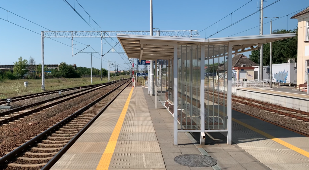
Oborniki Wielkopolskie Miasto railway stop. Geographical coordinates: 52.645N, 16.820E. Elevation 58 m (190 ft). Address: 64-600 Oborniki Lipowa Street 21 The stop is located on the railway line No 354 Poznań PoD – Piła Główna. The stop was built in 1947, on the initiative of local residents. Most of the work was carried out by the inhabitants. A small station building with a ticket office was built. The ticket office is currently closed. Two tracks run through the stop, both electrified. Currently, only one track is in use and the other is out of service. In 2017, the stop served up to 200 passengers and in 2022, up to 400 passengers.
Ostrów Wielkopolski railway station.
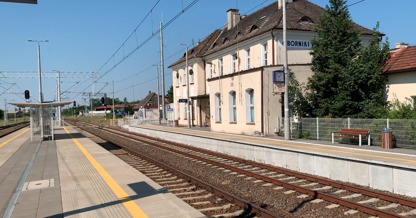
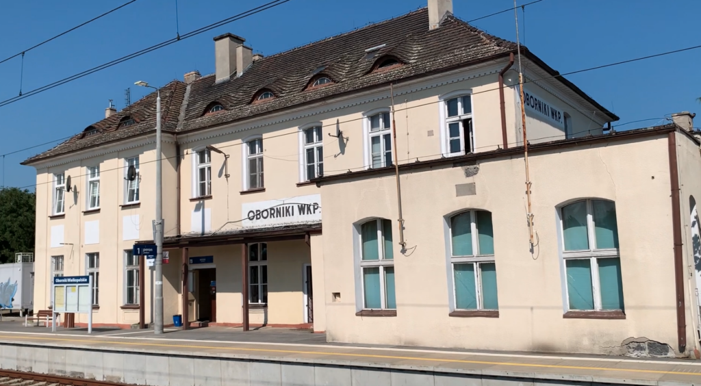
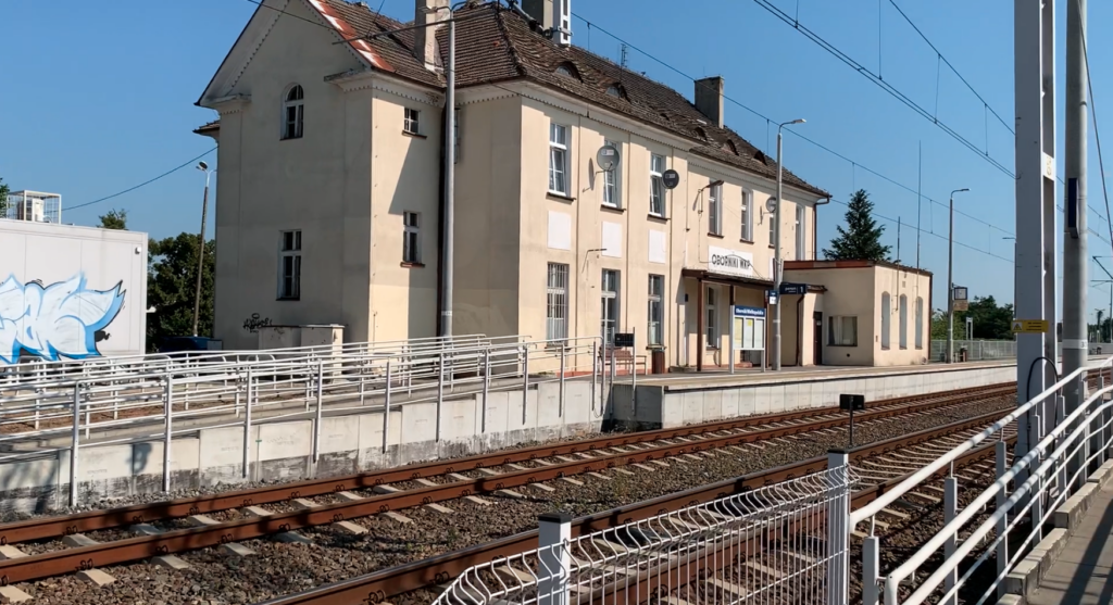
Geographical coordinates: 52.657N, 16.829E. Elevation 62.0 m (203 ft). The station was opened on 15 May 1879, with the opening of the Poznań-Piła route. According to the PKP classification, the station has the category of regional station. Initially, Oborniki Wielkopolskie station was named Oborniki. In 1919, after Poland regained its independence, the name was changed to Oborniki. After the Germanic invasion of Poland in 1939, the name was changed to Obornik, and in 1945, again to Oborniki.
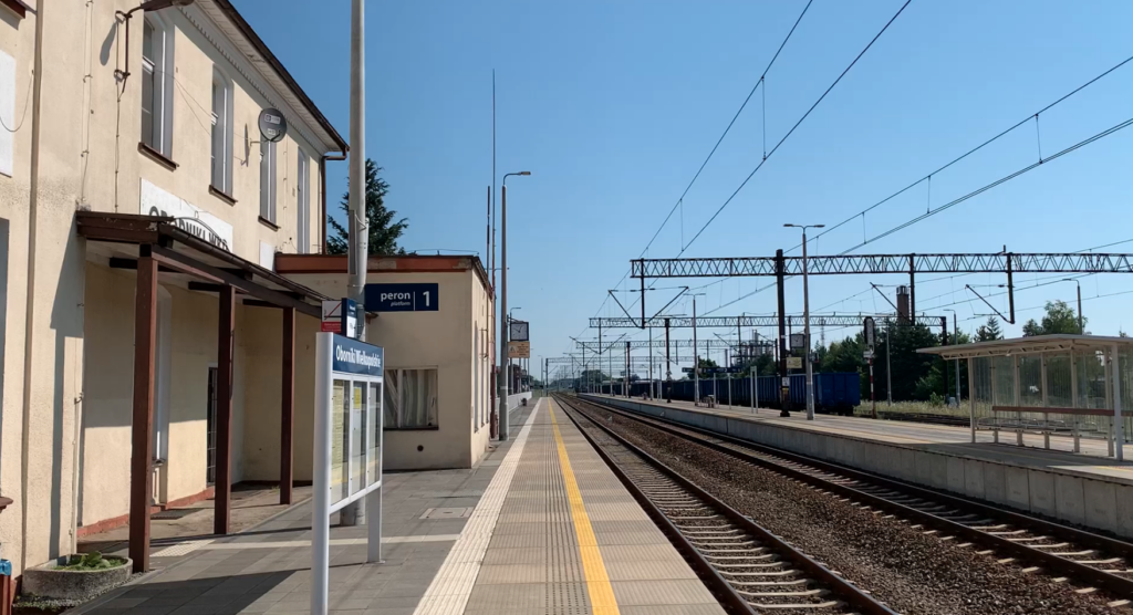
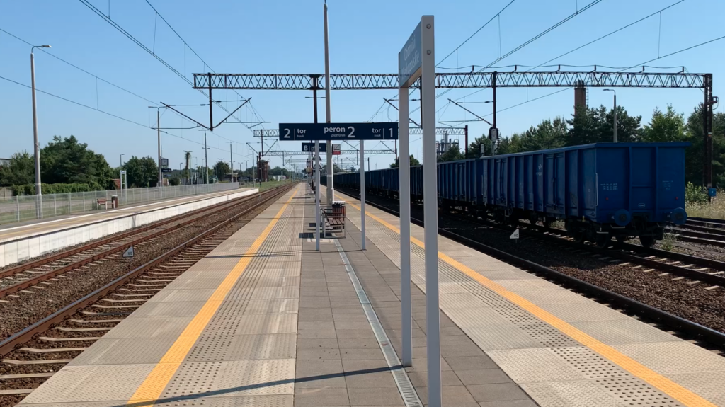
The station building was built in 1879 and has been extended and rebuilt several times in its history. The building housed a ticket office, a waiting room, a restaurant and flats for railway families. The ticket office is currently (2024) closed. The station has two platforms and three platform edges. Access to the platforms has always been at track level. The platforms were rebuilt in 2018.
The station has a water tower built in the late 19th century. The tower still stands today and is unused. The structure stands about 400 m from the station. The tower is octagonal and had two water tanks. A feature of the tower is the adjacent boiler house chimney.
In its history, about five railway sidings left the station, most of which led to local industries, in the eastern part of the town. For example, to FAM Zakład Oborniki.
Passenger traffic at Oborniki Wielkopolskie station is relatively high. In August 2024, 65 passenger trains departed from the station. One could go to: Bielsko-Biała Główna, Katowice, Kołobrzeg, Kraków Główny, Piła Główna, Poznań Główny, Przemyśl Główny, Rogoźno Wielkopolskie, Słupsk, Ustka, Wrocław Główny, Wyrzysk Osiek, Zebrzydowice. It is worth adding that not all InterCity trains stop in Oborniki. Passenger traffic is carried by the carriers: InterCity, PolRegio and Koleje Wielkopolskie. In 2017, the station served up to 700 passengers, and in 2022, up to 1,100 passengers.
Railway line no. 354 Poznań Główny PoD – Piła Główna.
Railway line No. 354 Poznań Główny PoD – Piła Główna was put into service on 15 May 1879. The track gauge is 1435 mm. The length of the line is 92.538 km.
Initially the line was single-track, but engineering facilities were already prepared for two tracks. The second track was added after 1886. As the Republic of Poland regained its sovereignty in 1922, the Dziembówko – Piła Kalina section was decommissioned. The section Piła Kalina – Piła Główna remained in Germanic hands. After 1922, the PKP decommissioned one track on the section Rogóżno Wielkopolskie – Dziembówko, and the tracks were used on other PKP routes. After the Germanic invasion of Poland, on 1 September 1939, the occupying forces opened traffic on the entire Piła – Poznań route. In 1945, the Soviets demolished the second track on the section Złotniki – Oborniki Wielkopolskie Miasto. In 1971, the second track on the section Oborniki Most – Złotniki post was rebuilt. Between 1988 and 1990, the entire Poznań – Piła route was electrified. During the electrification, wires were also laid on the second tracks in the Oborniki town area, which were no longer in use because they were awaiting renovation. In March 2018, a major overhaul of the route began, along with changing the track layout at stations, replacing tracks, control systems, renovating platforms, repairing level crossings and more. The major overhaul was completed in October 2018 and freight and passenger traffic was restored.
Currently (2024), the route is still single-track between Oborniki Most (25.395 km) and Dziembówko (82.098 km). The lack of a second track is used by local politicians as their important target. This is only a figure of speech, as the line is of state importance and decisions should be made in Warsaw. The idea was not realised when the United Right ruled, so much less will it be realised by the 13th-Grand Coalition (Volksdeutsche, Communists and Freemasons), which is systematically destroying Poland. The first element to restore the second track is the construction of a second bridge over the Warta river and, what is very important, the construction of a collision-free crossing in the course of Łukowska street (DW Nr 187), right next to the Oborniki Wielkopolskie Miasto stop. A second bridge also had to be built over the Noteć River. It should also be remembered that along the entire route, most of the crossings with circular roads are at track level, which is not conducive to safety. A positive example is the routing of the S11 Expressway.
Bridge over the Notec River.
The bridge over the Notec River is a trussed, single-span, riveted bridge with a single track. The bridge was last repaired in 2020.
Routing of line no. 354 Poznań Główny PoD – Piła Główna.
Poznań Główny PoD 0,000 km, (EBD Posen/EBD Bromberg 1895 – 1919). Poznan Podolany, 3,37 km. Poznan Strzeszyn, 5,10 km. Suchy Las, 6,30 km. Złotniki Grzybowe, 8,15 km. Złotniki, 9,52 km. Złotkowo, 11,25 km. Golęczewo, 13,90 km. Chludowo, 16,74 km. Wargowo, 19,42 km. Bogdanowo, 24.59 km. Oborniki Wielkopolskie Most, 25,40 km. Oborniki Wielkopolskie Miasto, 26.16 km. Oborniki Wielkopolskie City, 27.78 km. Rożnowo, 31.40 km. Parkowo, 35.91 km. Rogozno Wielkopolskie 42.51 km. Tarnowo Rogozińskie, 48.06 km. Sokołowo Budzyńskie, 51.83 km. Budzyń, 58.16 km. Ostrówki k/Chodzież, 63.48 km. Chodzież, 70.43 km. Between 1945 and 1947 the Chodzież-Dziembówko section was closed until the bridge over the Noteć River was rebuilt. Milcz, 77.46 km. (Western Regional Directorate/Pomeranian Regional Directorate 1984 – 1999), 79.45 km. Dziembówko, 82.09 km. (RBD Posen/RBD Danzig 1939 – 1945), 85,02 km. Polish-Germanic border, 85,85 km. Piła Kalina, 86.02 km. (DOKP Poznań/DOKP Gdańsk until 1975), 90.30 km. Piła Główna, 92,53 km.
Railway line No. 381.
The railway line No. 381 Oborniki Wielkopolskie – Wronki was opened in 1910, at a time when Poland was under partition. The first section of the line, from Wronki to Jaryszew Oborniki and the bridge over the Warta River, was put into service on 1 February 1910. The length of the line was 31.663 km. The line was single-track for its entire length and was never electrified. On 31 August 1991, passenger traffic was suspended on the line, and in 1994, freight traffic was also suspended. In 2005, the line was de-listed. By 2013, the entire line had been demolished. Of the route, the railway bridge Brączewo – Stobnica, which is now on the register of historical monuments, has been preserved.
The Brączewo – Stobnica railway bridge.
The railway bridge Brączewo – Stobnica is on the former railway line No. 381 Oborniki Wielkopolskie – Wronki and crosses the Warta River. The bridge is also known as the Bridge in Stobnica. Geographical coordinates: 52.702N, 16.605E. The bridge is located between the villages of Stobnica and Brączewo in the Greater Poland Voivodeship, on the border of the Szamotuły and Obornice districts. The bridge was built in 1910. The first train crossed the bridge on 8 May 1910. Technical trials were completed on 26 June 1910.
The total length is 245 m. The weight of the bridge is 600 tonnes. The bridge consists of seven spans ranging in length from 17.8 m to 83.3 m. The longest span has a truss structure. The other spans are of plate girder construction. All spans are steel, riveted. The bridge is supported by six stone and brick pillars, but no pillar stands in the riverbed. The longest span is over the main riverbed. The bridge is suspended 18.20 m above the water level. The track was laid on bridges.
The bridge was twice attempted to be blown up, due to the war effort. On 1 September 1939, the bridge was damaged by Polish sappers, but the Germans repaired it quickly. In 1941, the Germans built new spans for the heavier loads of goods trains. In 1945, the bridge was again destroyed by the Germanic army. Already in the autumn of 1945, the bridge was repaired.
In 2009, the bridge was entered in the register of historical monuments (reg. no. 716/Wlkp./A). It turned out that there were errors in the entry of the bridge in the register of historical monuments. The bridge was re-listed in September 2020. There are plans to revitalise the bridge for a cycle path.
Written by Karol Placha Hetman
Leave a Reply
You must be logged in to post a comment.